Jan van Stinemolen's 1582 Naples Panorama: A New Perspective
Miguel Fernández ·
Listen to this article~4 min
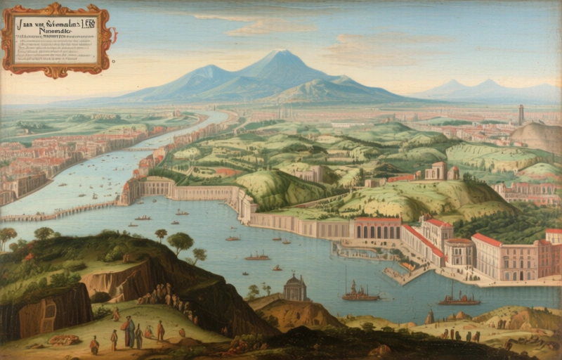
In 1582, Jan van Stinemolen drew Naples from a unique inland perspective. This overlooked masterpiece, now studied with digital maps, reveals it's far more than a simple snapshot.
Back in 1582, a Dutch artist named Jan van Stinemolen did something pretty remarkable. He created this massive, detailed panorama of Naples. But here's the twist – he didn't draw it from the usual spot out in the bay, looking back at the city. Nope. He positioned himself inland, up in the hills, and captured Naples from that completely different angle.
It's like looking at a familiar friend from their side profile instead of straight on. You notice things you never saw before. The drawing itself is ink on paper, and today it lives in Vienna's Albertina museum. You'd think such an original take would have scholars buzzing for centuries, right?
### A Surprisingly Overlooked Masterpiece
Well, that's the strange part. Even though experts in both Neapolitan geography and Dutch art history know about this work, it hasn't gotten the deep dive it deserves. It's been sitting there, waiting for someone to really unpack its secrets. Think about it – a 16th-century drawing that breaks the visual rules of its time, and we're only now giving it a proper look.
That's exactly what a recent collaborative research project set out to do. They decided to fill this gap in our understanding. And they brought some serious new tools to the party.
### The Digital Detective Work
The key to their approach was using digitized, annotated maps from the Bibliotheca Hertziana. This isn't just about staring at an old drawing anymore. It's about layering historical maps, modern technology, and sharp eyes to solve a 440-year-old puzzle.
The team had two clear goals. First, they wanted to identify as many locations in the panorama as possible. Where exactly was Stinemolen standing? What buildings, hills, and roads was he actually showing? Second, they wanted to analyze the drawing's artistic composition. How did he put it all together? What choices did he make?
- **Goal 1:** Pinpoint the real-world sites in the artwork.
- **Goal 2:** Decode the artistic and compositional choices Stinemolen made.
What they found was fascinating. This isn't a simple snapshot or a quick sketch. It's a carefully constructed piece of art and cartography blended together. Stinemolen wasn't just recording what he saw; he was interpreting it, composing it for a specific effect.
### More Than Just a Pretty Picture
That's the real revelation here. The research shows this panorama is "far from a simple snapshot of Naples in 1582." It's an intermedial construction – a bridge between a map and a landscape painting. It tells us not only what Naples looked like, but also *how* a skilled Northern European artist chose to see and represent a famous Southern European city.
It gives us a unique window into the cultural exchange of the period. What did a Dutch draftsman find noteworthy about Naples? What did he emphasize, and what did he downplay? The answers are all there in the lines and shading.
So, this project does more than just study one old drawing. It uses that drawing to start a new conversation. It connects art history with topography, and traditional scholarship with digital humanities. By finally giving Stinemolen's work the attention it merits, we're not just learning about Naples in 1582. We're learning about the very nature of observation, representation, and the stories we tell through images. And that's a perspective worth exploring.