Jan van Stinemolen's 1582 Naples Panorama: A Hidden View
Miguel Fernández ·
Listen to this article~4 min
In 1582, Jan van Stinemolen drew Naples from the hills, not the sea. This revolutionary panorama, long overlooked, is finally getting the deep analysis it deserves through modern digital research.
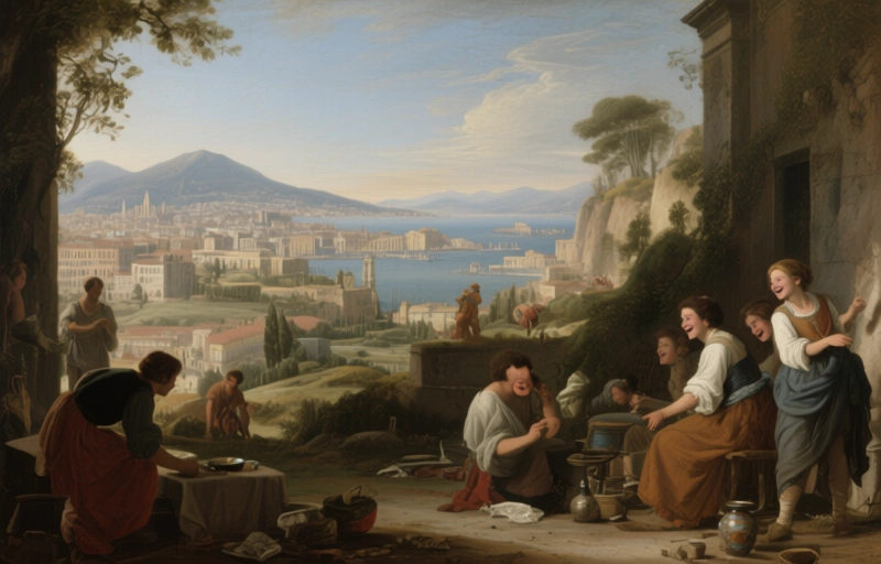
Back in 1582, a Dutch artist named Jan van Stinemolen did something pretty radical. He created a massive panorama of Naples, but he didn't draw it from the usual spot out on the water. Nope. He climbed up into the hills and looked back at the city from the mainland. It's a perspective flip that makes you see the place in a whole new light.
This incredible ink-on-paper drawing now lives in the Albertina Museum in Vienna. It's a technical marvel for its time, stretching several feet wide to capture the sprawling cityscape. But here's the thing that's always bugged me—despite being famous among map historians and art scholars, this piece hasn't gotten the deep dive it truly deserves. It's been sitting there for centuries, waiting for someone to really unpack its secrets.
### Why This Drawing Is Different
Most artists showing off Naples would set up their easel by the bay. You'd get the classic postcard view with Vesuvius in the background and ships in the harbor. Stinemolen turned his back on all that. By choosing a vantage point from the northern hills, he blended the urban landscape with the surrounding countryside. It wasn't just a portrait of a city; it was a statement about the relationship between culture and nature, between what humans build and the land that supports it.
This shift in perspective meant he included details others missed. We're talking farmlands, villas on the outskirts, and the winding paths that connected the city to its hinterlands. It gives us a more complete, more honest picture of what life in late 16th-century Naples was actually like.
### The Modern Research Breakthrough
Recently, a team of researchers decided to finally give this masterpiece its due. They launched a collaborative project with a clever twist: using digitized, annotated maps from the Bibliotheca Hertziana. This tech-forward approach let them overlay old maps with Stinemolen's drawing in ways that were impossible just a decade ago.
Their goals were straightforward but ambitious:
- Pinpoint as many real-world locations in the drawing as possible
- Analyze the artistic choices and composition techniques Stinemolen used
What they found was surprising. This wasn't a simple, objective snapshot. It was a carefully constructed piece of storytelling. The artist made deliberate choices about what to include, what to emphasize, and how to arrange the elements on the page. He was an editor, not just a recorder.
### What We Can Learn From It Today
Looking at this 440-year-old drawing now, it feels surprisingly modern. It reminds us that every representation of a place is a choice. When we look at a map, a satellite image, or even a social media post, we're seeing a version of reality filtered through someone's perspective.
For professionals working with historical visuals or urban landscapes, Stinemolen's work is a masterclass in narrative cartography. It shows how an artist can guide the viewer's eye and tell a complex story about geography, society, and power—all without writing a single word.
The research also highlights the power of interdisciplinary collaboration. By bringing together art historians, geographers, and digital humanities experts, the team could ask better questions and find answers that would have remained hidden if they'd worked alone.
As one scholar involved in the project noted, "Sometimes you have to change your physical position to change your intellectual understanding." Stinemolen knew that instinctively when he climbed those hills. Now, centuries later, we're finally climbing up there with him, seeing Naples through his eyes, and discovering all the layers he so carefully put on paper.