Decoding Jan van Stinemolen's Panorama of Naples
Miguel Fernández ·
Listen to this article~5 min
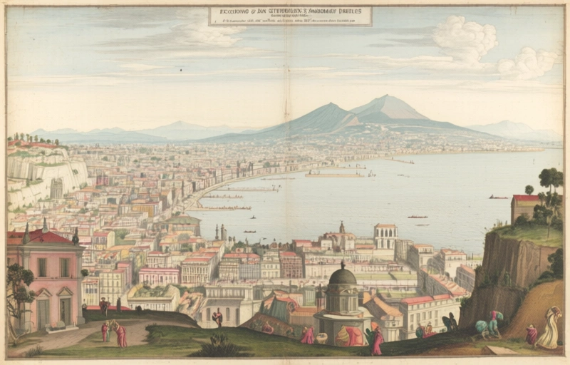
Explore Jan van Stinemolen's 1582 Panorama of Naples—more than a simple drawing, it's a complex artistic construction revealing Renaissance perspectives on urban space through collaborative research.
Let's talk about something that's way more than just an old drawing. Jan van Stinemolen's *Panorama of Naples* from 1582 isn't what it seems at first glance. It's not a simple snapshot of the city back then. Actually, it's a complex artistic puzzle that researchers have been trying to solve for years.
I want to walk you through what makes this work so fascinating. We'll look at how a recent collaborative project approached it, and why this drawing deserves your attention if you're serious about historical art and cartography.
### What This Panorama Really Is
First off, forget everything you think you know about panoramic drawings from the Renaissance. Stinemolen's work isn't just a pretty picture of Naples. It's a carefully constructed piece of art with layers of meaning. The research team discovered it's what they call an "intermedial construction"—meaning it blends different artistic approaches and media in ways that weren't obvious at first.
Think of it like this: it's not just showing you where buildings were. It's telling you a story about power, perspective, and how people understood space in the 16th century. The drawing reveals how the artist selected what to include, what to emphasize, and what relationships to show between different parts of the city.
### The Research Project's Two Goals
The collaborative project had two clear objectives from the start. They weren't just trying to catalog what was in the drawing—they wanted to understand why it was made the way it was.
Here's what they focused on:
- Identifying as many actual sites as possible within the panorama
- Analyzing the artistic composition and construction methods
That second point is crucial. By looking at how Stinemolen put this together, researchers uncovered his artistic choices. They found he wasn't just documenting—he was interpreting, selecting, and arranging elements to create a specific impression of Naples.
### The Tools That Made It Possible
This research didn't happen in a vacuum. The team had access to some incredible resources that changed how they could approach the panorama.
They worked with digitized maps from the Bibliotheca Hertziana that had been carefully annotated. These weren't just scans of old maps—they were enhanced with layers of information that helped connect Stinemolen's drawing to actual geography. The annotations pointed out landmarks, showed changes over time, and provided context that made the panorama much more understandable.
Without these resources, the project would have been much harder. They allowed researchers to move back and forth between the artistic representation and the historical reality of Naples in 1582.
### Why This Matters for Professionals
You might be wondering why this specific drawing deserves so much attention. Here's the thing—it represents a turning point in how cities were represented artistically.
> "This work is far from a simple snapshot of Naples in 1582. It's a deliberate construction that tells us as much about the artist's perspective as it does about the city itself."
That insight changes how we look at similar works from the period. It suggests artists weren't just trying to be accurate—they were making statements, choosing viewpoints, and creating narratives through their representations of urban spaces.
For professionals working with historical art or urban history, this has big implications:
- It challenges assumptions about "accurate" historical representations
- It shows how artistic and cartographic traditions blended in the Renaissance
- It provides a model for analyzing other panoramic works
- It demonstrates the value of collaborative, interdisciplinary research
### What We Can Learn Moving Forward
The most exciting part of this project isn't just what they discovered about this particular drawing. It's the approach they developed that can be applied to other works.
By combining art historical analysis with digital mapping tools, they created a methodology that bridges different fields. They showed how looking at something from multiple angles—literally and figuratively—can reveal layers of meaning that would otherwise remain hidden.
This matters because we have so many historical works that we've taken at face value. What if they're all more complex than we realize? What if every panoramic drawing, every city view, every map from this period has similar hidden depths waiting to be uncovered?
The project on Stinemolen's panorama gives us both specific insights about Naples in 1582 and general tools for understanding historical representations of space. It reminds us that artists have always been interpreters, not just recorders, of the world around them.
And that's a perspective worth keeping in mind whenever we look at historical art. The surface might show us a city, but the real story is in how that city was seen, understood, and presented by the artist who captured it.